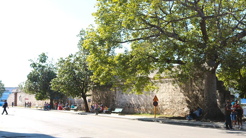
La Puerta de la Tenaza is located at the point where the Avenida de Bélgica connects to the Avenida del Puerto.
Parallel with the economic development of the
island, the port of the Village of San Cristóbal de la
Habana became the center of the commercial activity due to
its geographical advantage, characterized by its narrow
entrance and deep waters; a feature, that makes the port a
safe haven for the ships with a deep draft. Furthermore,
Cuba had a strategic location, as being the key to the
Mexican Gulf that rendered the port of Havana an inevitable
stopover for the ships that were carrying the assets of the
New World to the old continent. Thus, the city faced
numerous attacks of the pirates that were endangering the life of the
habaneros and the goods of the Spanish Crown that had been
stored in the town. Even though, the attacks of the pirates
led the Spanish Crown to position a more powerful fleet in
the Caribbean Sea, to fortify the defense of Havana by the
castles of La Fuerza, La Punta, El Morro and La Cabana, and
to build some turrets, such as Torreón de la Chorrera,
Torreón de San Lázaro and Torreón de Cojímar, all these
efforts were not sufficient to defend the flourishing city.
As a response to the increasing threats against the
city, Cuba's anxious colonial authorities drew up plans for
the construction of a city wall to make the city
impregnable. There were some proposals, such as building
wooden walls around the city or enclosing the city by a
moat, but all these were rejected. In 1603, a project was
designed by the military engineer Cristóbal de Roda to
create a wall around the city to prevent the access of the
enemies on the land side. The four feet wide and eight feet
high wall would be made of bricks, and it would extend from
Campeche (an old, outlying section in southwest of Old
Havana, owned its name to the natives from Yucatán
Peninsula, Mexico that were brought to Cuba as slaves
in the early 16th century) to Castillo de San Salvador de La
Punta, but the project couldn’t carried out because of the
numerous bureaucratic procedures, presumably done to mask
the lack of fund that the Spanish Crown would grant.
This project was forgotten for several years until
the commercial competition between Spain and other powers,
such as England and Holland, became fierce in the second
half of the 17th century. This led the Spanish Crown to take
further measures to fortify Havana not only against the
pirates, but more critically against the foreign armies,
thereby protecting its overseas possessions. Thus, the old
project of encircling the city by wall re-handled in 1667.
In 1674, during the rule of the General Captain Francisco Rodríguez de Ledesma, the construction of the wall of Havana began under the direction of the engineer Juan de Siscaras. The construction process progressed very slowly due to technical problems. First the land part was completed in 1698, and then the bay part in 1740. Although initially the construction was planned for a three-years period, it lasted for 66 years. According to some authors, the construction of the whole wall completed in 1797, when some moats are added. The project was completed at a cost of about 3 million pesos.
The land part of the city wall was running along the Monserrate
street (currently Avenida de Bélgica), starting on the south of the city from the point where the
Avenida del Puerto (Desamparados street) connects to the Avenida de Bélgica, until it met the shore in front of the Castillo de San Salvador de la Punta. The bay part extended along the shore until it met the land part of the city wall. The whole length of the city wall that had an irregular polygon shape, was 4.892 meters. It was 10 meters high and 1,4 meters thick in average. The stones were extracted from several quarries, including Arsenal and Barracones in Consulado close to Prado. Particularly the rocks, extracted from the reefs of the coast from La Punta to San Nicolás, were used as the main material of the wall. It is estimated that about 75.000 m3 of ashlar was used in the construction. The manpower was supplied by the slaves.
By passage of time the city grew, particularly in the direction of north, and more activities were being carried out outside of the wall. The urbanization of the area outside the wall developed faster than the area inside the wall. Major avenues and commercial districts were built outside the wall. New works
like the Aldama Palace, the Prado Promenade and the Tacón Theater, became the preferred sites of the
habaneros. The prestige of possessing an intramural mansion or a store tailed off. The wall began to represent an obstacle for the traffic and the commerce, so that the existence of the wall became less necessary. Furthermore, the wall afforded little military benefit.
In 1841 the authorities petitioned the Spanish Crown for permission to demolish the wall. In 1863 the demolition began in a solemn ceremony with the collapse of the wall around the gate of Monserrate, presided over by the Captain General Domingo Dulce. This was the first public act, in that the governor appeared in a photo. Once again, the African slaves were put to work to destroy what their forefathers had built more than one century ago. The demolition of the wall progressed little by little until the beginning of the 20th century.
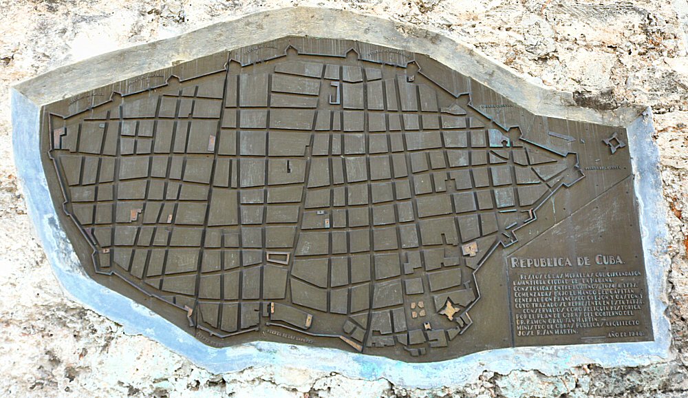
Today there are only scattered remains, the largest being La Puerta de la Tenaza (about 100 meters long). It is located at the point where the Avenida de Bélgica connects
to the Avenida del Puerto (Desamparados street). There is a large door, and an embedded map
at the wall that illustrates the wall around the Old City and indicates the gates. This gate was opened with a drawbridge between the bastions of the same name and that of San Isidro in 1745. It was purposed to facilitate the access to the arsenal that was being built at that time, but twenty years later it was closed by the captain general. Its function was replaced by the Puerta de la Teneza.
Some disperse remnants of the walls can be seen in front of the Estación Central del Ferrocarril (Central Railway Station), in front of the Museo de la Revolución, in the Avenida de las Missiones, in the Refugio street, in Teniente Rey street,
along the Cuba Tacón street and adjacent to the Iglesia de San Francisco de Paula.


